Wednesday, June 20, 2007

How to work on international assignment.

After you record your path with Garmin GPS device, bring the device to me, I will take the data file off, and post it online.(I will send you URL)
Also, please make notes of which file is who's path.( Ex:”10-JUN-07: Mariko 1, 10-JUN-07 002 :Lisa 1) .

Here is what you are going to do.

1. sign on to Google Maps (don't use NN class account, you have your own account. use same username/password as you use for blogger)

2. search the URL I sent you. the path will show up on the map


3. click “my map” tab


4. create new map, and annotate. (in anycase you lost your path, always saech the URl agin)

5. After you finish annotation. click "link to this page".

6. Copy the URL and send the URL to me.


After I got your annotation link, I will combine two file (path and annotation) together and create full annotated path.
It would be nice if you could send me the annotation link by Tuesday night(6/26). so that I can make all the completed file by Wednesday class.

Garmin how to.

How to use Garmin

1. Turn on Garmin.

2. Wait a little bit until they get satellite information.(do it outside. inside of the building, you might not get satellite signal.) If they couldn't find location data, move a little bit, hit ”new location” and try until you get satellite.

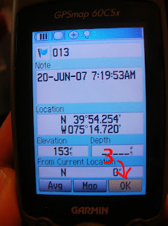
3. on the start point, hit “MARK” and select “OK” to save the location. (always hit "enter" to select something)


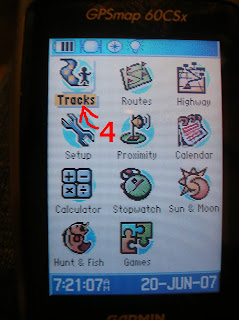
4. then hit MENU button twice. select “Tracks”


5. select “on” (once you hit on, it start automatically tracking your path.)

IMPORTANT: make sure you start from memory 0%. other wise it will just add your path to the log created in past. to clear the memory select "clear"

6. at the end point hit mark button and select “OK” to save it.

7. Then hit MENU twice, select “Tracks”.

8. select "Save"

9. Turn track log "off".

10. “clear” your log.

11. Turn off Garmin

my following


Monday, June 11, 2007

Drifting

my pics: http://flickr.com/photos/kosamari/sets/72157600338131784/
my path: here annotated ver. here
artifacts: in class

I have map(s)/Lost

I have a map/Lost.

I always carry my map inside of my notebook both in Philly and in Rome. Also In tokyo when I go somewhere I don’t know, I always carry my map. Map is my life line.
I think before I stared biking in city, I didn’t know how to read map. I was really bad at knowing direction to somewhere.
Now I know how to use map and it is such important element of my biking life.
I’m so glad that both Philly and Rome map fits inside of the book. In Tokyo, I need to carry twice as thick book all maps.
One more map I love. “Google maps” it is amazing application. so now not only Google the word I don’t now, I Google the address I’m not familiar with.

Although I had map, I once lost in Rome.
Than was first day in Rome, after we had dinner. I was in the middle of historic center, near Spanish steps. Now it is easy to know where I am and how to go back, but at that point, I didn’t know where I am. I usually have good sense of going back home, but that day I was lust lost, and biking around the city. I tried to guess where I am from street name, but I couldn’t. Finally I have got to Trevi fountain, and happened to know where I am.

Monday, June 4, 2007

How To my Map.

1. Go to google maps
2.Click my map tub

3. Click Sign in

4. sign in


5. Click "Rome Map"


6. and start editing.


7.If you click rich text, it will allow you to put pictures, change font and size and etc...as you do on blogger.


Please Make sure you are editing "Rome Map" so that we all editing same map.
At the end of this class we will have our collective information map!!